Decode the Gurgaon Master Plan 2031 to spot high-growth real estate sectors across Gurugram. This comprehensive infrastructural layout outlines the city's zoning laws, green buffer reserves, and commercial transport hubs. Discover how planned high-density residential sectors, massive highway systems, and upcoming metro extensions will systematically reshape regional real estate values and maximize long-term yields for property investors.
Gurugram, earlier known as Gurgaon, has transformed from a suburban extension of Delhi into one of India’s most dynamic real estate markets. This rapid growth has been guided by structured urban planning, with the Gurgaon Master Plan 2031 serving as a blueprint for the city’s future. Gurgaon Master Plan 2031 explains how Gurugram will grow through planned residential, commercial, industrial, transport, utility, and green zones. For homebuyers and investors, it helps identify suitable sectors, understand upcoming infrastructure, and assess land-use restrictions. This guide covers the plan, allocations, connectivity proposals, verification steps, and risks before purchasing property. The Gurgaon Master Plan is prepared by the Haryana Town and Country Planning Department. It focuses on balanced urban expansion, infrastructure development, and sustainable land use. This plan is crucial for homebuyers and investors. It directly influences property prices, growth corridors, and long-term investment potential.
What is the Gurgaon Master Plan 2031?
The Gurgaon Master Plan 2031 outlines the city’s development strategy across approximately 33,000+ hectares of urbanizable area. The master plan aims to accommodate a population of over 4 million people while ensuring efficient land use and infrastructure. The Master Plan 2031 focuses on:
Decentralized urban growth
Expansion towards Dwarka Expressway, Sohna, and New Gurgaon
Improved connectivity through highways, metro, and transit corridors
Allocation of land for residential, commercial, industrial, and green zones
Gurgaon Master Plan 2031 Download PDF
You can download the Gurgaon Master Plan 2031 PDF from the official Department of Town and Country Planning, Haryana government website. Link: Gurgaon Master Plan 2031 Download PDF Source attribution: According to Haryana’s Town and Country Planning Department, the official development-plan document defines the city’s planned land-use framework.
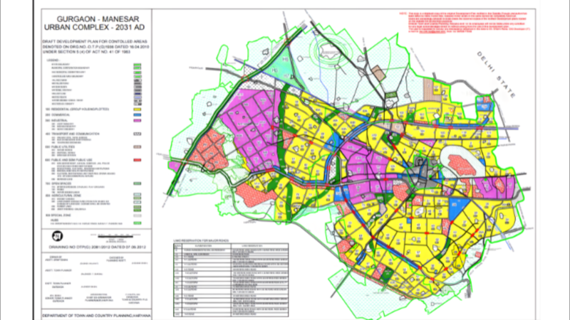
Gurgaon Master Plan 2031 map showing development plan
Proposed Land Uses
The plan divides Gurgaon into multiple land-use categories to ensure organized development:
Sr. No.
Land use
Area (in Hectares)
Each category is carefully planned to balance growth with livability.There are 3 types of land uses under the Master Plan 2031, these include:A total of 16,021 hectares has been designated for residential use to support an expected population of 4.25 million. Within this Development Plan, the Haryana Urban Development Authority (HUDA) and builders have created residential zones covering 8,000 hectares across several residential sectors.These public and private residential zones are set to house 2 million people, while existing town and village areas account for another 200,000. To handle the rest of the expected growth, the Development Plan has mapped out new residential areas to support an additional 2.05 million residents.The Gurgaon Master Plan 2031 builds these areas around a "neighborhood" concept. This ensures that every sector has its own local amenities and services right where people live, maintaining an average density of 250 people per hectare.To keep the environment livable as the population grows, the plan introduces a few key rules:The government is also working on a new approach to . By capping sale prices and managing the allotment process directly, they aim to make sure quality homes stay within reach for everyone, regardless of their budget.The Gurgaon Master Plan 2031 earmarks 1,616 hectares for commercial development, with 480 hectares already completed by HUDA. The plan focuses on building high-end corporate hubs and ultra-modern shopping malls to support the city's growing business needs.A key highlight is the creation of 200-meter-wide commercial belts along major highways. These are strategically placed to boost economic activity and provide nearby residents with easy access to essential services.Furthermore, a dedicated 48.50-hectare zone in Sector 99A, near the Delhi-Rewari railway line, has been reserved for wholesale trade. This specialized market for building materials and fresh produce will be managed exclusively by the government to ensure organized and efficient trading.The Gurgaon-Manesar Master Plan has reserved 4,613 hectares for industrial growth, specifically targeting eco-friendly high-tech sectors like software and automotive manufacturing.So far, the HSIIDC and HUDA have developed 1,246 hectares to support current business needs. The newly planned industrial zones are strategically located near major highways and the existing , ensuring excellent connectivity for regional commerce.To tackle the increasing traffic pressure within the Gurgaon-Manesar Urban Complex, the 2031 Master Plan introduces several vital road links connecting Delhi to the upcoming Sohna township. These infrastructure projects include a 90-meter-wide road network linking Vasant Kunj in Delhi to Mehrauli Road, and another 90-meter-wide corridor connecting Andheria Mor to the Gurgaon-Faridabad Road via Gual Pahari.Additionally, a massive 150-meter-wide road is planned to run through Dwarka in Delhi, joining NH-8 just before the Gurgaon Toll Plaza. For internal connectivity, a 90-meter-wide road will link the Sector 63A/64 intersection with the 's main roads. To support the expanding urban footprint, sector-dividing roads with widths of 75 and 60 meters are also prioritized, alongside the already established 16-hectare automobile market in Sector 10.Logistics and heavy transport management are centered in Sector 33, where a 28-hectare Transport Nagar has been established by the Haryana Urban Development Authority. To prepare for future growth, new Transport Nagars and Container Depots are proposed near the Garhi Harsaru Railway Station along the Delhi-Rewari line. Furthermore, a 45-hectare site near Garhi Harsaru Village has been specifically reserved for idle parking. This ensures that heavy vehicles have a dedicated space, preventing congestion on city roads and facilitating the smooth transport of goods.The existing metro connectivity, which currently concludes at HUDA City Centre (Sector 29), is set for a significant extension. The new route will pass through Sectors 43-44, 52, and 56, eventually reaching Manesar via the (SPR) and NH-8. Additionally, a metro loop starting from Sikanderpur and covering Sectors 25-25A is nearing completion. There are also proposals to extend this network along to the SPR, offering residents and daily commuters more efficient and seamless travel options across the city.A new Mass Rapid Transit System (MRTS) corridor is planned to run alongside the 150-meter-wide link from Dwarka to the Inter-State Bus Terminal (ISBT) at Kherki Daula. The 162-hectare ISBT site is designed to serve as a combined terminal and MRTS depot. Regional travel will also be transformed by the Regional Rail Transit System (RRTS), which will connect Delhi to Alwar through Gurgaon along the NH-8 corridor. These projects follow an Integrated Mobility Plan designed to prioritize motorized, non-motorized, and pedestrian safety.To ensure the city can support its future population, 608 hectares of land have been earmarked for public utilities across Sectors 37D, 99A, 100, 101, and 107. The government is also exploring the feasibility of laying underground power lines for high-capacity (66 KV) transmissions. For waste management, the Bandhwari estate continues to serve as the regional site for solid waste disposal, with current facilities equipped to handle the requirements of both Gurgaon and Faridabad.To meet the institutional needs of a projected population of 42.5 lakh, the plan allocates 2,027 hectares for public and semi-public use. While HUDA has already developed 135 hectares, a significant institutional belt (ranging from 172 to 200 meters in width) is planned south of the outer peripheral road to house various government and semi-government offices. Additionally, Sector 68 will host a 215-hectare university campus, marking a major investment in the city’s educational infrastructure.Greenery and safety remain paramount in the 2031 plan. Following the Works of Defence Act, a 900-meter-wide non-development zone is maintained around the ammunition depot. Dedicated green belts will also line the Delhi-Jaipur Highway, major railway lines, and the Badshahpur Nallah. For recreation, expansive open spaces are planned near villages like Basai and Dhanwapur, complemented by a 135-hectare Biodiversity Park on the Mehrauli-Gurgaon Road near the state boundary.A vast portion of land remains designated as an agricultural zone to preserve local ecosystems. While this limits urban sprawl, it does allow for the essential expansion of existing village communities and the development of agricultural maintenance facilities. A key project in this zone is a 50-hectare dairy farming and *Gaushala* hub in Dhankot. All existing city dairies will eventually move to this organized facility. The plan also incorporates geo-referenced forest maps to protect reserve forests and established wildlife corridors.The Aravalli Ranges are strictly protected as a Natural Conservation Zone. Within this region, only eco-friendly activities like social forestry, horticulture, and limited local recreation are permitted. To prevent ecological damage, construction is restricted to just 0.5% of the total area. Strict environmental safeguards are in place, including the protection of the Sultanpur National Park eco-sensitive zone and a ban on groundwater pumping within 5 km of the Delhi-Haryana border. Sustainable measures, such as mandatory rainwater harvesting in all new buildings, are also enforced to restore groundwater levels.The Gurgaon-Sohna Master Plan 2031 is a strategic roadmap designed to manage the booming real estate market in the Sohna corridor. The plan envisions Sohna growing into a major satellite town, accommodating 6.4 lakh people across 5,600 hectares of urbanizable land. With the approval of this plan, the region is poised for a surge in regulated residential and commercial projects, providing a more optimized and balanced real estate environment for future homeowners and investors.The Gurgaon Master Plan 2031 is more than just a planning document; it is a roadmap for the city’s future.It focuses on:For homebuyers and investors, this plan provides valuable insights into high-growth areas, infrastructure projects, and future appreciation potential. Understanding the Master Plan can help you make smarter and more informed real estate decisions.At , we simplify real estate decisions with data-backed insights and curated property options.Whether you are investing in emerging corridors like Sohna or established sectors, TOI Homes helps you make confident property choices.
Frequently asked QuestionsFAQs
Gurgaon Master Plan 2031 is a government-approved development blueprint that outlines land use, infrastructure, and urban growth, helping buyers identify high-potential investment areas in Gurugram.
Keywordsgurgaongurgaon master plan 2031gurgaon master plan 2031 pdfgurugram master plan 2031gurgaon land use plan 2031gurgaon infrastructure projects 2031sohna development plan 2031toi homesgurgaon metro and transit plans
Disclaimer: The information presented by TOI Homes, part of The Times of India Group, is for general informational purposes only and does not constitute financial, legal, or investment advice. All data and insights are based on sources believed to be reliable but are not guaranteed for accuracy or completeness and are subject to change due to market conditions. The developer and associated entities are not liable for decisions made based on this information. Real estate investments involve risks, and buyers are advised to conduct independent due diligence and consult certified advisors before investing. TOI Homes does not endorse or promote any specific property or developer unless explicitly stated.
1
Residential
16,021
2
Commercial
1,616
3
Industrial
4,613
4
Transport and Communication
4,428
5
Public Utilities
608
6
Public and semipublic
2,027
7
Open spaces
2,928
8
Special zone
114
9
Defence land
633
–
Total land (urbanisable)
32,988
10
Existing town
406
11
Village abadies
478
–
Grand total (plan area)
33,872
Description of Land Uses
Residential
Commercial
Industrial
Residential Land Use
Managing Density:
Additional space for infrastructure will be allocated even in sectors that are already complete.
All internal roads must be at least 12 meters wide to prevent traffic jams and ensure easy access.
Every resident gets at least 2.5 square meters of dedicated park and green space for recreation.