A property may look perfect on paper. It may be close to an IT hub, have good road access, and sit in a neighborhood that is growing quickly. But before you invest, there is another question worth asking: what do the official planning records say about the land?
This is where the
Bangalore Master Plan 2031 comes in. Prepared by the Bangalore Development Authority (BDA), the Revised Master Plan 2031 was intended to guide Bengaluru’s land use, transport networks, residential development, public facilities, and open spaces.
However, there is one important information. The Karnataka government withdrew the provisional plan in 2020. Its archived documents remain available for research. But the withdrawn document should not be treated as the current basis for learning a property’s development rights.
The Bangalore Development Authority has also intiated a new planning exercise with a 2041 horizon. Plus, the Greater Bengaluru Authority (GBA) has pursued a separate GIS-based master plan for its local planning area.
This guide explains what the 2031 draft contained, where to find its maps and documents, how to understand its land-use categories, and what property buyers should verify before making a decision.
Bangalore Master Plan 2031?
The Bangalore Master Plan 2031 is also known as the Revised Master Plan 2031. It was a long-term urban-planning exercise that guides development across the BDA’s local planning area.
It coordinates land use, housing, commercial activity, transport, public utilities, and environmental protection as Bengaluru expands.
A master plan helps planners learn how different parts of
Bangalore should develop. It identifies areas intended for housing, business, industry, public facilities, roads, and open spaces. Plus, provides framework for coordinating infrastructure with urban growth.
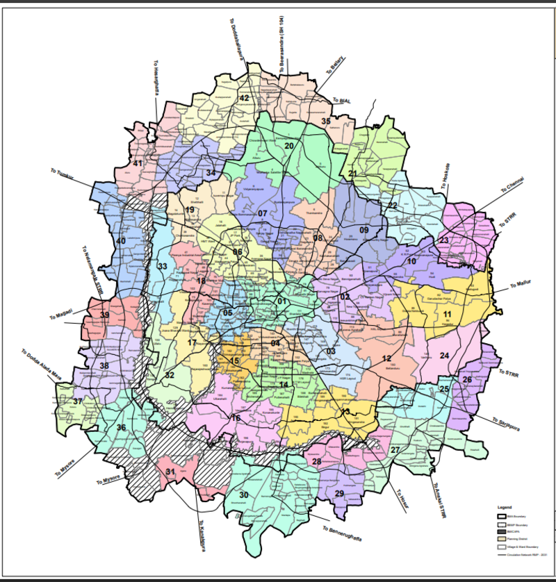
The BDA’s archived 2031 documents include a vision document, the main master-plan document, planning district reports, existing and proposed land-use maps, and zoning regulations. These materials offer insight into the planning approach proposed at the time.
However, the plan’s history matters. The state government withdrew permission to prepare the provisional RMP 2031 in June 2020. The withdrawal means readers must distinguish the draft’s historical proposals from the rules and approvals that currently apply to a particular property.
TheBDA’s master-plan page lists the 2031 document under draft plans, while OpenCity’s BDA Revised Master Plan 2031 archive provides access to the supporting documents and maps.
Key Takeaways- Plan status: The provisional Revised Master Plan 2031 was withdrawn in 2020.
- Historical reference: Its archived documents contain proposed land-use maps, planning district reports, and zoning regulations.
Bengaluru’s rapid expansion has increased pressure on housing, roads, public transport, water supply, drainage, and public spaces. Planning these systems independently can lead to uneven development and gaps in civic infrastructure.
The 2031 draft aimed to establish a coordinated framework for the city’s growth. Its planning themes included:
For researchers, the archived plan offers historical context. For property buyers, it can help explain earlier proposals for a locality. However, its maps should not replace current official records when evaluating a property.
You can find the Bangalore Development Authority (BDA) Revised Master Plan 2031 PDF files and maps on these websites:
These resources provide access to historical planning material. The availability of a PDF or map online does not mean the document remains legally operative.
The archived Revised Master Plan 2031 documents show different land-use categories based on the planning approach proposed at the time. These categories help explain how planners intended to organize residential, commercial, industrial, public, and environmental uses across the planning area.
The table below provides a general explanation of the categories discussed in the draft. It is not a statement of current permissions for any specific property.
The precise definitions and permitted uses depend on the applicable planning documents, regulations, and property-specific approvals. Do not use the historical categories above as a substitute for current verification.
Residential land use refers to areas intended for housing and related activities. It is relevant to homebuyers, landowners, and developers assessing a property's development potential.
However, a residential designation does not automatically permit every type of construction. Building height,
, setbacks, road access, layout approval, and other requirements can affect what may be built.
If you are planning a residential plot, first verify its current land-use classification. Plus, the rules that apply. Do not just rely on a broker’s description, an old map, or the presence of nearby buildings.
Commercial land use generally covers business activities such as offices, retail spaces, and other permitted commercial uses.
These areas can help businesses evaluate potential locations and allow investors to research the commercial character of a neighborhood. However, commercial zoning does not automatically permit every business activity.
The intended use must comply with the applicable regulations, access requirements, and building approvals. Verify these details before purchasing property for a commercial purpose.
Industrial land use is intended for industrial and related activities permitted under the applicable planning framework.
This distinction matters when buying land for a factory, warehouse, or other business use. It also matters to residential buyers who want to understand the land uses around a prospective home.
Do not assume that industrial land can be converted to residential or commercial use without the necessary permissions. Confirm the property's current classification and any conversion requirements before proceeding.
Public and semi-public categories generally cover land intended for schools, hospitals, government facilities, and other institutional uses.
Such allocations help planners provide essential services as a city grows. They can also influence nearby neighborhoods by affecting access to education, healthcare, and public facilities.
For a buyer, the key question is whether the property’s legally permitted use matches the intended development. Land reserved for public or institutional purposes should not be treated as an ordinary residential plot without proper verification.
Transport and communication categories cover infrastructure such as roads, railway networks, and related facilities.
Transport planning can influence how people travel between homes, workplaces, commercial centers, and public amenities. Better connectivity can also affect a locality’s accessibility.
However, a proposed road or transport corridor shown in a historical draft does not guarantee that the project will be funded or completed. Check the latest official status of an infrastructure project before using it as a reason to purchase property.
Open spaces, agricultural land, forests, and water bodies form an important part of urban planning. They help preserve natural resources, support recreation, and protect environmental features.
These categories also matter during property due diligence. Land near a lake, drain, forest, or designated open space may be subject to specific restrictions or buffer requirements.
A vacant plot is not necessarily developable land. Confirm its current designation, environmental requirements, and legal development status before committing money.
The main difference is that the 2031 plan is a withdrawn draft, while the 2041 initiatives represent newer planning exercises. These processes should not be treated as one completed replacement plan.
The BDA has invited bids for preparing a GIS-based Revised Master Plan 2041 for its local planning area. Separately, the GBA has pursued a GIS-based master plan for the Greater Bengaluru Local Planning Area.
These initiatives have different scopes and responsible authorities. A property’s everyday locality name may not be enough to establish which planning authority governs it.
The newer planning exercises are intended to address Bengaluru’s future development needs. Public reporting has highlighted issues such as vertical development, land-use planning, and infrastructure coordination. However, proposals discussed in the news should not be confused with final, approved planning rules.
Here, are the important developments to watch:
In May 2026, news websites reported that officials were considering a policy shift to accommodate more vertical development in Bengaluru. The discussion included a possible review of FAR and planning rules.
These were proposals under discussion, not confirmation that new citywide rules had been finalized. Buyers and developers should continue to verify the building regulations that apply to a specific project.
The BDA has initiated procurement for preparing a GIS-based Revised Master Plan 2041 for its local planning area. Tender records available in October 2026 list October 27 as the bid-submission deadline and October 28 as the technical bid-opening date, following extensions.
These dates are procurement milestones. They do not confirm that the tender has been awarded or that the plan has been completed or approved.
The GBA has also pursued a GIS-based master plan for the Greater Bengaluru Local Planning Area. Its official tender document, dated December 24, 2025, invited agencies to prepare the planning framework.
The original tender schedule was subsequently superseded by later procurement activity. For this reason, readers should consult the
and its
for official information rather than relying on the original deadline.
These initiatives reflect ongoing planning work. Neither should be described as a completed, approved replacement for the withdrawn 2031 draft without an official notification confirming that status.
The 2031 draft can provide historical context, but buyers should focus on the current legal and planning position of the property they intend to purchase.
Before booking a home or buying land:
This process helps distinguish genuine development opportunities from assumptions based on old maps or proposed infrastructure.
The historical 2031 draft offers insight into how planners intended to organize land use, development density, transport, and public facilities. Its relevance to an individual property today is limited by its withdrawn status and by the property's applicable planning records.
Historical residential designations can help explain the draft's intended pattern of housing development. But buyers must confirm current land use, layout approval, building permissions, access, and other legal requirements before purchasing a property.
Commercial and industrial allocations can help readers understand the economic geography envisioned in the draft. They may offer context for researching employment access and surrounding development.
They do not guarantee that a proposed office district, commercial center, or industrial hub will be delivered on a particular schedule.
Roads and transport networks can influence accessibility and commuting patterns. However, the impact of a proposed corridor depends on its approval, funding, construction progress, and eventual operation.
Do not base a property purchase entirely on an infrastructure proposal shown in an older planning document. Check the project's current official status.
Historical land-use maps can help readers understand which areas were proposed for open space, agriculture, forests, and water bodies.
These features can be important when researching a plot, but the archived map cannot confirm current development rights. Verify applicable environmental rules, buffer requirements, and the property's legal status through current records.
If you are buying a plot or evaluating a residential project, use historical master-plan documents only as background research. Your decision should rely on current official records and property-specific approvals.
Follow these steps:
The BDA’s master-plan page and OpenCity’s 2031 archive are useful starting points for research. For current planning information, also consult the responsible authority’s official records.
An online map, a broker’s explanation, or the existence of nearby construction should never be the sole basis for a property decision.
The Bangalore Master Plan 2031 provides historical context for understanding Bengaluru’s proposed land-use framework, zoning categories, and approach to urban development. Its archived maps and reports remain accessible and can help readers explore the planning ideas developed for the city.
But the state withdrew the provisional plan in 2020, so the draft should not be treated as the current basis for determining a property’s development rights. Newer planning exercises are underway through the BDA and GBA, and their scopes should be understood separately.
For homebuyers and investors, the practical takeaway is simple: use the Bangalore Master Plan 2031 as a historical reference, then verify current zoning, planning authority, property approvals, and infrastructure status through official records. A well-informed property decision depends on the rules and permissions that apply to the property, not simply on what an older draft proposed.
For support with exploring residential options in Bengaluru, TOI Homes can help buyers assess properties and identify the right questions to ask before making a decision.